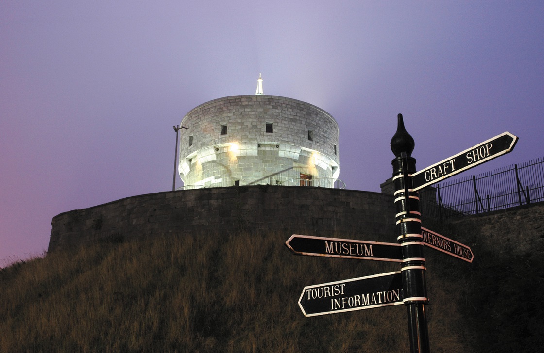
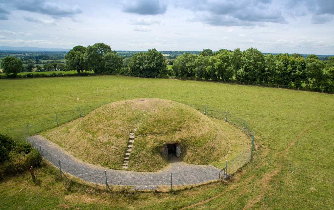
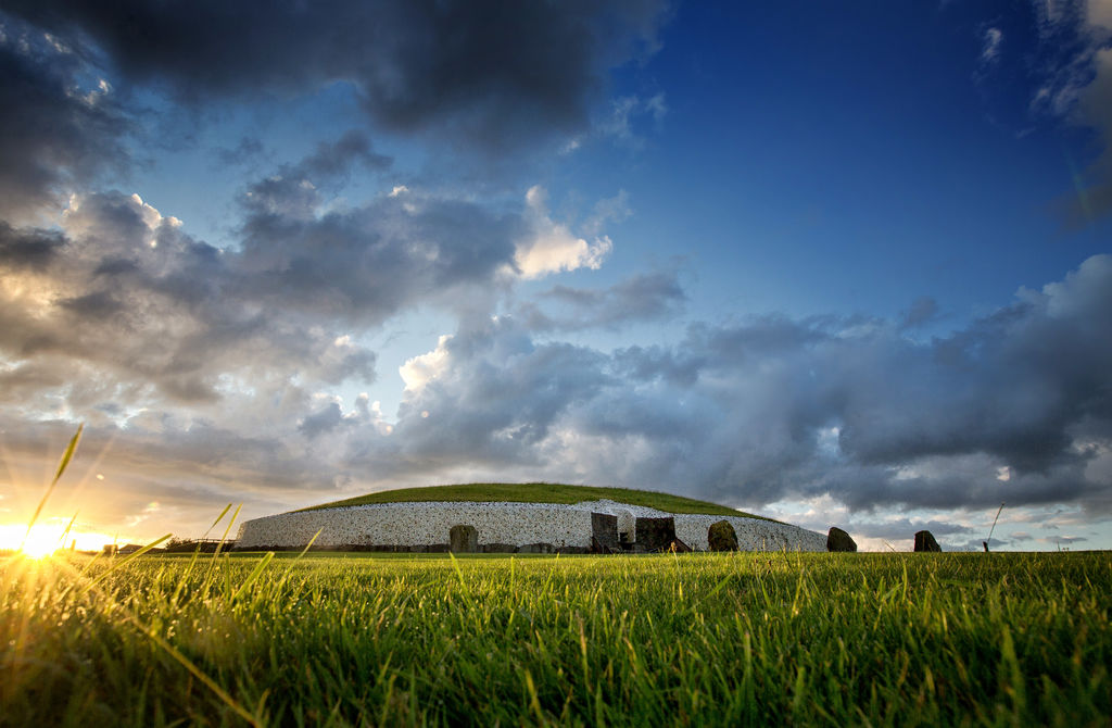
Boyne Valley Drive Sites | Discover Boyne Valley

Boyne Valley Drive Sites

Collon House

Built in 1740 in the Irish Long House style, Collon House was the home of Anthony Foster, Lord Chief Baron of the Exchequer.

Collon House, steeped in history, is full of character and charm; its gracious rooms are exquisitely furnished with period antiques and paintings, retaining the atmosphere of early Georgian living, making this a rare opportunity to experience less than one hour from Dublin City Centre, and thirty minutes from Dublin Airport.

00 353 87 235 5645
collonhousereception@gmail.com

Collon House Collon Co. Louth

View location on Google Maps

Arriving by car

Collon House is in the centre of Historic Collon village on the N2 Dublin Derry/Londonderry road, 55kms/35 miles north of Dublin City.Or if driving from Dublin/Airport North on the M1, take junction 10, and the Collon Road, if driving Southbound on the M1, take junction 12, and the Collon Road.

Arriving by Bus/Coach

Fast and frequent coaches operate between Collon and Dublin city centre, see collinscoaches.ie for timetables.Local buses operates to Drogheda, to connect with expressway services, see buseireann.ie

Arriving by Train

The nearest Irish Rail/Iarnrod Eireann station is Drogheda, 9 miles away, see irishrail.ie for timetable.

https://www.facebook.com/pages/Collon-House/572335932820797
53.7782
-6.4864

Donaghmore Round Tower & Cemetery

Saint Patrick is said to have first founded a monastery here, giving charge of it to one of his followers, St. Cassanus. The existing ruins, however, do not date back that far. The architectural style of the church indicates it was built in the 15th Century. Most likely, it replaced an older church built in the Romanesque style; a carved Romanesque head is incorporated in the south wall of the bell tower. The round tower predates the church and was built in the 9th or 10th century. It is well-preserved though missing its conical cap.

Slane Road,Navan

View location on Google Maps here 

From Dublin take the M3 motor way(this road is tolled), leaving at Exit 8 or N3 to Navan, on continue through Navan and take a right just beyond the turn for Kentstown, you will see a sign N 51 Kingscourt /Drogheda, go up Flower Hill and keep right round the roundabout at the Round O public house. The cemetery is about a mile on the left-hand side of the Slane road, you will see a sign with a P (Park) & + Cross, turn left here and a few yards up this road you will see a Round Tower and gate leading to the cemetary.

Via M1 Motorway or Drogheda: From the M1 (this road is tolled) coming from Belfast, take the exit for junction 10, take the N51 exit to Slane/Drogheda North. At the roundabout, take the 3rd exit onto N51 headed for Slane. If coming from Drogheda take the N51 headed towards Slane also. Continue on the N51 through slane towards Navan after approx 9kms there should be signage for Donaghmore Round Tower & cemetary

Free

53.6707
-6.66245

Donaghpatrick Church

Saint Patrick`s Church was built in 1896, designed by J.F. Fuller, an authority on the Hiberno-Romanesque style

In 1862 the London-trained Fuller had answered an advertisement for a district architect under the Irish Ecclesiastical Commissioners; he was chosen from among 97 candidates: St. Patrick`s is one of his finest creations.

Donaghpatrick Church and site

Donaghpatrick,Teltown,Co. Meath

View location on Google Maps here 

From Dublin take the M3 motor way (this road is tolled), leaving at Exit 9 At the roundabout, take the 3rd exit onto N51, Go through 2 roundabouts, At the roundabout, take the 1st exit onto Kells Road/R147. Continue to follow R147, (6km) Turn right toward Windtown Road, Turn left onto Windtown Road, Donaghpatrick, Co. Meath

Via M1 Motorway or Drogheda: From the M1 (this road is tolled) coming from Belfast, take the exit for junction 10, take the N51 exit to Slane/Drogheda North. At the roundabout, take the 3rd exit onto N51 headed for Slane. Coming from Drogheda take the N51 headed towards Slane also. Continue on the N51 through Slane. At the roundabout, take the 3rd exit onto N51, Go through 1 roundabout, (13km) Turn right onto Ratholdren Road, Continue onto Windtown Road for 3km and then you reach Donaghpatrick.

Free

53.6964
-6.76

Drogheda Museum, Millmount

Millmount Museum and Martello Tower are situated on high ground in the heart of Drogheda near to where the river Boyne. Shortly after the Anglo-Norman King Henry II granted him the Kingdom of Meath in 1172, Hugh de Lacy constructed a motte and bailey on a huge mound overlooking the River Boyne. A more substantial stone fort replaced the earlier structure. According to Irish mythology, the mound was the burial place of Amergin mac Míled, druid, bard and judge of the Milesians. Amergin was the son of Míl Espáine and brother of éremón (see Myths & Legends, p. 52).

+353 (0)41 9833097
info@droghedamuseum.ie

Millmount Museum, Millmount Complex,Drogheda,Co. Louth
F: +353 (0)41 9841599

View your location on Google Maps here 

Getting here - Drogheda Museum Millmount is located in the centre of Drogheda town on the south of the river Boyne. Buses and cars should turn into of the Dublin Road onto Mary Street at the Memorial, facing the new Scotch Hall Shopping Centre, and drive to the top of the hill. Turn right into Duleek Street and follow the road turning left into the Millmount Complex.

On foot from the Train Station follow the same route as above. From the Bus Station, Town Centre of tourist Office eirther take the steps to the right of Ollies Public House or walk up Barrack Lane to the Millmount Complex which is directly across the road from the Millmount Public House. Visitor Information

9:30 - 17:30

(Last trip to the Tower is at 16:30)

https://www.facebook.com/DroghedaMuseumMillmount/

Museum  and Tower

Adult:    €6.00          
Child / Student / OAP:   €3.00          
Family:    €12.00


53.7119
-6.35024

Duleek Abbey

Duleek Abbey began life as a monastic settlement when, in 450 AD, Patrick, the Patron Saint of Ireland, established a bishopric there.

Duleek derives from the Irish Damhliag, meaning ‘stone house or church' and refers to the 5th Century construction, possibly the first stone building in Ireland and the ruins are still visible today.

+353 (041) 982 33 15

Duleek Heritage Group,Newlanes House,Duleek

View location on Google Maps here 

From M1 Motorway

Take exit 8 and follow the R152 to Duleek.

From Navan

Take the R153 to Kentstown and take a left in Kentstown along the R150 for Duleek crossing the N2.

From Drogheda

Take the R152 out of Drogheda for Duleek

Access year round

Free

53.662
-6.39388

Four Knocks

Four Knocks is a neolithic passage tomb built about 5000 years ago. It is located 10 miles southeast of Newgrange between Ardcath in County Meath and the Naul in County Dublin. The name Fourknocks may be from the Irish Fuair Cnocs meaning Cold Hills.

+353 (0)46 943 1352 (OPW)

Fourknocks,

Stamullen,

Co. Meath

View location on Google Maps here 

The key for the entrance door to Fourknocks Passage Tomb can be obtained from the White family +353 (0) 1 8354722 before 6pm who live over a mile from the Tomb . Directions are signposted from Fourknocks  (see map below).
The house (Eircode A42 FN40) is found west of the tomb - turn left at the Y-junction with the white and green house then keep going straight up the narrow track where the main road turns to the left. The Whites' house is some distance up here - the 5th on the right.
A cash deposit must be given which is refundable on the safe return of the key. The key should be returned before 6pm.
The entrance is via a stone stile, there is no access for wheelchairs.

Four Knocks Map

Directions to Fourknocks from Drogheda:

Travel 14 km via Duleek to Ardcath Village.

Travel South East towards Garristown for 1.5 km (passing the school and church).

Turn left at cross roads towards Clonalvy (Fourknocks is signposted).

Travel for 2 km (passing Donnellys Pub in Clogherstown on the right).

Turn left onto a narrow road.

Travel for 0.5km to collect key at White's house which has a plaque with the name WHITE built into the stone wall at the roadside. There is a red hay barn behind the house.

Travel 1.5 km to a STOP sign where the road joins an equally narrow road, keep to the left.

Travel a short distance to a fork in the road, keep to the right towards Naul.

Travel for 175 meters, the Fourknocks pedestrian entrance is on the left hand side.

The pedestrian entrance is unsuitable for wheelchairs.


Directions to Fourknocks from Dublin and the Naul:

Take the M1 northbound, and exit at Junction 6.

Turn left on to the R122 towards Naul

Drive 5km to Naul village.

In Naul, turn right onto the R108, towards Drogheda.

After 2km turn left onto the L5624, signpost for Clonalvy.

Drive 2.5km, Four Knocks tomb is on your right.


Exterior of site open 24/7.

Access to monument: The key for the entrance door to Fourknocks Passage Tomb can be obtained from the White family +353 (0) 1 8354722 before 6pm who live over a mile from the Tomb . Directions are signposted from Fourknocks.
The house (Eircode A42 FN40) is found west of the tomb - turn left at the Y-junction with the white and green house then keep going straight up the narrow track where the main road turns to the left. The Whites' house is some distance up here - the 5th on the right.
A cash deposit must be given which is refundable on the safe return of the key. The key should be returned before 6pm.
The entrance is via a stone stile, there is no access for wheelchairs.

53.596625394939736
-6.3264664844144685

Francis Ledwidge Museum

Introduction to Francis Ledwidge

+353 (0)41 9824544
info@francisledwidge.com

Francis Ledwidge Museum Janeville,Slane,Co. Meath C15DK82

View location on Google Maps here 

By car:

The Francis Ledwidge Museum is located in Janeville, Slane, Co. Meath. Travel on the M2 from Dublin to Slane. The museum can be found on Janeville Street.

Open All Year

Summer Period - 10th March – 27th October

The museum is open 7 days a week from 10.00am to 5.00pm

Winter Period - 28th Oct – 9th March

The museum is open 7 days a week from 10.00am to 3.30pm


Christmas opening times have not been decided yet, check website for up to date opening times.

Tours can be booked in advance and there are special rates for schools and teachers.

https://www.facebook.com/FrancisLedwidgeMuseum

Adult € 3.00 Senior / Students € 3.00

Child € 1.00 Family € 6.50

Coach Tours € 2.00 per person

Coach Tours

It is advisable that coach tours contact the museum in advance.

53.7067
-6.52803

Highlanes Gallery

Highlanes Municipal Art Gallery, is one of Ireland's most important visual art spaces.

Highlanes Municipal Art Gallery, which opened in 2006, is one of Ireland's most important visual art spaces. Serving the North East region, it presents a programme of national and international temporary exhibitions, as well as exhibitions drawn from the Drogheda Municipal Art Collection, a fascinating collection dating from the mid-18th century.

+353 (0)41 9803311
info@highlanes.ie

Highlanes Gallery,Laurence Street,Drogheda,Co. Louth

View location on Google Maps here 

Rail

Drogheda is serviced by both Intercity (Dublin/ Belfast) and Suburban trains (Dublin/Drogheda/ Dundalk) with trains departing approximately every half hour from 07:30 - 23:20 daily. For more info see www.irishrail.ie or call +353 (0) 41 9838749.

Bus

Drogheda is serviced by both Intercity (Dublin/Dundalk/ Belfast) and Suburban bus services (Dublin/ Drogheda/ Dundalk),in addition to other national routes, with buses departing from 07:15 - 00:00 daily. For more info visit www.buseireann.ie or call +353(0) 41 9835023.

By Car

From the Nort:

Take the M1 south to Drogheda and exit at the N52 / Drogheda off-ramp (immediately before the M1 Boyne bridge) and follow the signs for town centre.

From the south:

Take the M1 north to Drogheda and exit at the N52 / Drogheda off-ramp (immediately after the M1 Boyne bridge) and follow the signs for town centre.

From the west:

Take the N52 via Navan / Slane, cross over the M1 (with the M1 Boyne bridge to the south) and follow the signs for town centre.

Once in the town

Once in the town Turn on to West Street (adjacent to the Bridge of Peace)•At the end of West street go straight through the junction up St Laurence Street and the gallery is at the top of the hill on the right - slightly offset from the street•Note there is no parking within the gallery complex.

There are several parking options in Drogheda – visit www.highlanes.ie for more details on directions and parking.

Highlanes Gallery are open Monday to Saturday 10.30am-5.00pm, and will remain closed on Sundays. It will be open on key Sunday and Bank Holidays throughout each year including May Bank Holiday Weekend to coincide with the Annual Drogheda Arts Festival, and the October Bank Holiday Weekend.

Admission to the Gallery is free – visitors may choose to leave a token donation, suggested at €2.

53.7158
-6.34793

Hill of Skryne

Skryne, or Skreen as it is officially known, is a small village situated on and around a hill. The hill is a short distance east of the Hill of Tara and the area is sometimes referred to as the Tara/Skryne Valley. One can enjoy wonderful views of each hill from the summit of the other. In the 12th century, Hugh de Lacy granted the Barony of Skryne to his finest knight, Adam de Feipo. He subdivided it and granted twenty of his followers with land grants.

Hill of Skryne,

Skryne,

Co. Meath

Eircode (O'Connell's Pub): C15 EY76

View location on Google Maps here 

From Navan:

Get on the R147 heading towards Dublin. Continue on this road (through three roundabouts) for about 11Km. Take a left at Ross Cross for Skryne. Continue on the Old Ross Road until you come to the next crossroads. Take a left for The Green at Swans Pub and then take the first left after you turn. Arrive at the Hill of Skryne. From Trim: Take the R154 headed towards Dublin/Clonee. After 10Km turn left toward Knightsfield Park. Continue straight onto Knightsfield Park. Continue onto Old Ross Road. Turn left onto R147 and then take the immediate right for Skryne onto Old Ross Road. Continue on the Old Ross Road until you come to the next crossroads. Take a left for The Green at Swans Pub and then take the first left after you turn. Arrive at the Hill of Skryne.

Via M1 Motorway or Drogheda:

Take the M1 (this road is tolled) coming from Belfast. At junction 7, take the R132 exit to Julianstown/Balbriggan (North). At the roundabout, take the 1st exit onto R132. Turn left onto R150. Turn right onto R150/R152. Take the 1st left onto R150. Turn left onto N2. Turn right onto R153. Turn left for the road towards Trim. Continue on this road until you reach Skryne. Take a right for The Green at Swans Pub and then take the first left after you turn. Arrive at the Hill of Skryne.

From Dublin:

Take the M3 (this road is tolled) headed for Cavan. At junction 6, take the R125 exit to Dunshaughlin/Trim. At the roundabout, take the 3rd exit onto R125. At the roundabout, take the 1st exit and stay on R125. At the roundabout, take the 1st exit onto R147. At Ross Cross turn right for Skryne onto Old Ross Road. Continue on the Old Ross Road until you come to the next crossroads. Take a left for The Green at Swans Pub and then take the first left after you turn. Arrive at the Hill of Skryne.

Free access.

Free access.

53.5843
-6.5629

Hill of Slane

The Hill of Slane rise 158m above the surrounding countryside and can be seen from the Hill of Tara, 16km away.

A well-preserved tower is to be found among the ruins of a Franciscan Monastery, dating from 1512, itself built on site of a monastery founded by St. Erc, a follower of St. Patrick.

+353 (0) 41 9824000 - Local tourist office
slaneforummail@gmail.com

Slane, County Meath

View location on Google Maps here 

From Dublin head north on the N2 to Slane. Drive straight through Slane and about 600 metres after the crossroads take the first left sign-posted Hill of Slane. Drive up here to the car-park. Walk straight across the field. The mound is situated in the trees behind the monastic site.

From Navan head east on Kells Road toward Flower Hill, Turn left onto Flower Hill, at the Roundabout take 3rd exit onto Slane Road/N51, continue to follow N51, at Slane Village turn left at the traffic lights about 600 metres after the crossroads take the first left sign-posted Hill of Slane. Drive up here to the car-park. Walk straight across the field. The mound is situated in the trees behind the monastic site.

From Drogheda Head west on Patrick Street toward George's Street, Turn right onto George's Street, Continue onto North Road, Continue onto R132, At the roundabout, take the 1st exit onto N51, Go through 2 roundabouts, approaching Slane village take the right at the traffic lights, about 600 metres after the crossroads take the first left sign-posted Hill of Slane. Drive up here to the car-park. Walk straight across the field. The mound is situated in the trees behind the monastic site.

24/7

Free

53.717194217890764
-6.5431438949987974